Milliken’s Fallacious Account of Puichon Territory
Jonathan Cordero, Ph.D.
Part I. Milliken's Fallacy
|
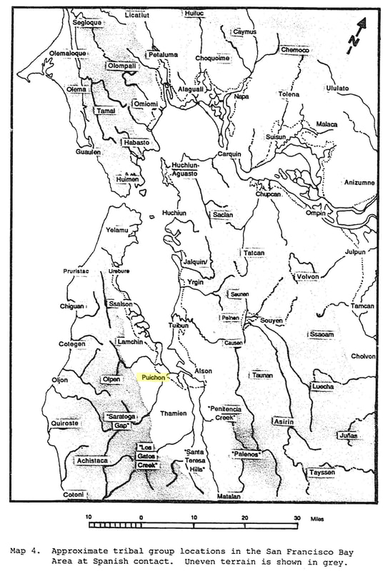
In the San Francisco Bay Area, the boundaries of Puichon territory have been unclear and highly contested for many years. Randall Milliken is credited with being the first to delineate the boundaries of Puichon territory. Milliken’s conclusion is that “[t]he Puichons held the west shore of the San Francisco Bay between lower San Francisquito Creek and lower Stevens Creek.”[i] The problem with Milliken’s erroneous placement of Puichon territory is that it has been reproduced on other subsequent maps. While the location of the northern boundary of Puichon territory along San Francisquito Creek is not contested, the extension of Puichon territory to Stevens Creek is not supported by reason and evidence, and is based instead on an error in reasoning, a logical fallacy. Map 4. Approximate tribal group locations in the San Francisco bay Area at Spanish Contact. Uneven Terrain is shown in grey. (Milliken, Randall. 1991. “An Ethnohistory of the Indian People of the San Francisco Bay Area from 1770–1810.” PhD diss., University of California at Berkeley, 340.) |
|
|
The evidence and explanation in support of the delineation of Puichon territory can be found in Milliken’s dissertation (1991).[ii] To support his conclusion that Puichon territory extended to Stevens Creek, Milliken offers two premises. First, Milliken claims that “[t]hose Puichon who went to Mission Santa Clara were noted . . . indirectly, as being from the Auloquis tribe.”[iii] To support the first premise Milliken offers a second: “At Mission Santa Clara the term ‘San Bernardino’[iv] was probably [italics mine] first applied to a specific Puichon village [i.e., Auloquis] in the Moffat Field area on lower Stevens Creek. One San Bernardino convert was baptized in 1789 at the village of the Yambloquis [i.e., Auloquis] about two leagues to the north of this mission.”[v] The lower end of Stevens Creek is about two leagues (5.4 miles) northwest of Mission Santa Clara.
|
|
|
Extracted from the information above, Milliken’s argument regarding Puichon territory can be understood as containing the following premises:
1. Some[vi] of the “Puichon who went to Mission Santa Clara were noted . . . as indirectly being from the Auloquis tribe.” 2. The “specific Puichon village” of Auloquis was located on lower Stevens Creek.” 3.Stevens Creek was within Puichon territory because the Auloquis who lived at Stevens Creek were Puichon. These premises Milliken offered in support of the conclusion that Puichon territory extended from San Francisquito Creek to Stevens Creek. What begs to be proven is how Milliken knows that the Auloquis who lived at Stevens Creek were Puichon. Instead, Milliken assumes that the Auloquis were Puichon yet offers no evidence to support that claim. A related error in logic is that the Auloquis tribe cannot be the same as Puichon tribe, unless Auloquis refers to a village located within Puichon territory and not to a tribe. Milliken refers to the Auloquis as both. |
Milliken's Uncertainty The late Randall Milliken was an innovate scholar and a tireless researcher. I was honored to know him before his passing. Like all academics, Randay's scholarship was not without error, a truth Randy acknowledged. The broad scope of his research limited his capacity for more detailed and sophisticated analysis. Milliken, at times, noted the limits of the evidence at hand to make determinations about the location of villages and tribes. He noted numerous difficulties associated with “reconstructing tribal geography” and asserted that the map of Bay Area tribal groups “illustrates only tentative relative locations.” When mapping the Alson tribe Milliken confessed, “I am not at all certain about the specific territorial boundaries of the group.” |
Part II. Begging the Question
An example from Gracie Allen and George Burns: Gracie: Gentlemen prefer blondes. George: How do you know that? Gracie: A gentleman told me so. George: How did you know he was a gentleman? Gracie: Because he preferred blondes. |
One serious problem undermines Milliken’s entire conclusion: he has constructed a logical fallacy referred to as begging the question (a type of circular reasoning). Begging the question is an argument in which the conclusion is taken for granted and included in one (or more) of the premises. If the author assumes as evidence in their argument the very conclusion they are attempting to prove, they engage in the fallacy of begging the question. Milliken begins by assuming that Puichon territory extended to Stevens Creek, and then constructs his argument assuming that it is true instead of proving that it is. Milliken integrates the assumption that Puichon territory extended to Stevens Creek in his premises.
There is, however, absolutely no direct or indirect evidence that the Auloquis were directly or indirectly identified as being Puichon. None whatsoever. (For more information see, "Notes on Milliken's Use of Indirect Evidence.") Even if the Auloquis did occupy the village at Stevens Creek, that so-called fact does not prove that the Auloquis were Puichon. Any other evidence and explanation offered in support of that conclusion becomes superfluous.[ix] |
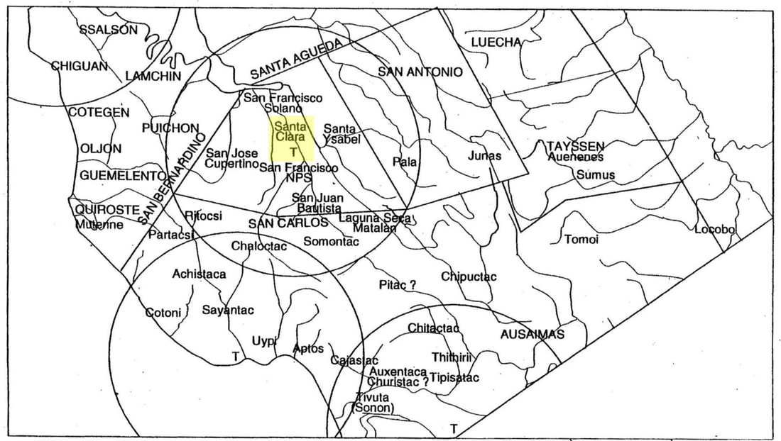
Map of the San Bernardino District according to Chester King
|
Distribution of Ohlone Tribal Groups and Tribal Districts in the Santa Clara Valley. Mission Santa Clara is highlighted. (“Central Ohlone ethnohistory.” In The Ohlone past and present: Native Americans of the San Francisco Bay region. Lowell John Bean editor. Ballena Press Anthropological Papers, No. 42. Menlo Park, CA.)
|
The Franciscan missionaries at Mission Santa Clara predominantly used districts instead of village, family, and tribal names to identify the origin of Native converts. The district within which Milliken locates the Puichon was referred to as the San Bernardino District. With Mission Santa Clara as the point of reference, the San Bernardino district extended directly north to the head of the San Francisco Bay, northwest to San Francisquito Creek, and west to Quiroste territory. This description of the San Bernardino District, based on an analysis of mission records, conflicts with King's description of the San Bernardino District as including lands primarily to the northwest and west of Mission Santa Clara. The San Bernardino district was immense and included numerous villages and tribes.
Part III. Puichon Territory
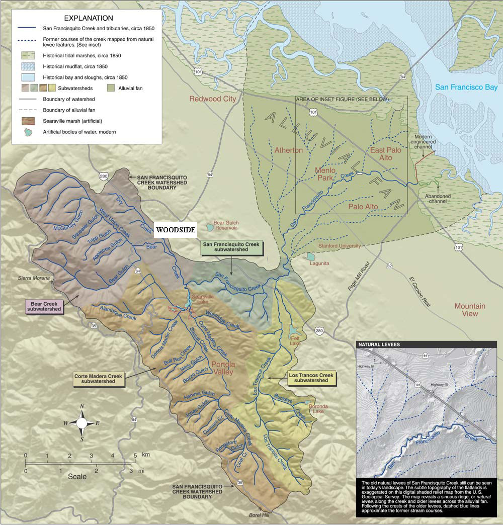
So what do we actually know about the Puichon and their respective territory? In brief, Puichon territory was bounded by the northern branches of San Francisquito Creek and Redwood Creek to the north, by the mountain ridge to the west, and by the main branch of San Francisquito Creek to the Bay shore. Their territory includes at least five known villages and at least one tribal head located at the village of Sipánum near present day Woodside, although each village had its own leader. There is no evidence in the mission records at either Santa Clara or Dolores indicating that Puichon territory extended further south than the San Francisquito Creek watershed.
The San Francisquito Creek Watershed (https://www.sfcjpa.org/about-the-watershed)
|
Another related error made by Milliken was his conflating of the Quemelenta with the Olpen. Milliken considers the Olpen and Quemelenta to be one in the same tribe. Contrary to Milliken’s claim, the Olpen and Quemelenta were different tribes. While the information on the Olpen and Quemelenta at Mission Dolores is limited to about ten records, as Milliken acknowledges, one record provides clarifying information.[x] Milliken focused upon that single baptismal record--Mission Dolores baptism record 575. In his reading of the record, Milliken mistakenly writes that Salustina was “from the nation of the Guemelentos,”[xi] when the record states instead that her parents were from “east of the Gemelentus Nation on the edge of the Sierra where the San Francisco stream rises along the coast.”[xii] Further, Salustina’s mother, Veronica was from the Olpen village at Muiugpe near the intersection of Los Trancos and San Francisquito Creeks.[xiii]
Milliken (1991 and 1995) and Milliken et al. (2009) position the Quemelenta/Olpen tribe to the west and southwest of the Puichon: “From a few hints in the records that indicate their homeland was in the upper drainage of San Francisquito Creek we infer that they held [the] interior hill and valley lands of La Honda Creek on the coast side, as well as the Corte Madera Creek portion of the upper San Francisquito Creek watershed [southwest of the Puichon].”[xiv] That location better fits the information on the Quemelenta than the Olpen. The Quemelenta appear to be perhaps the only tribe without shoreline access along the San Francisco Peninsula. |
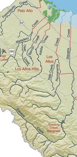
Map of the Matadero Creek and Adobe Creek Watershed. (https://explore.museumca.org/ creeks/1420-OBStevensPermBig.html) |
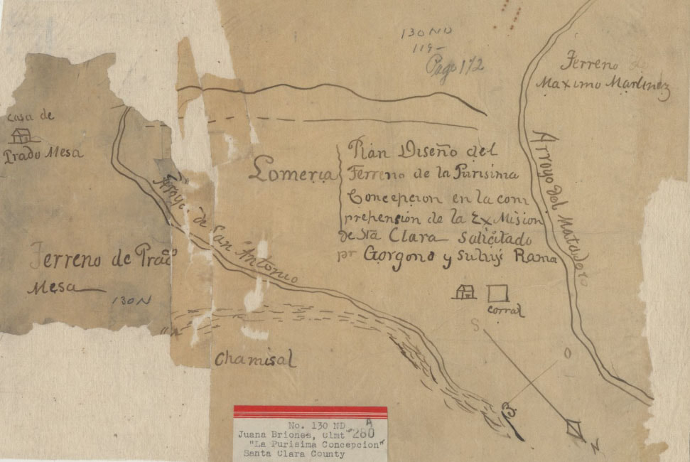
Plan diseño del Ferreno de la Purisima Concepcion (Title: Plan diseño del Ferreno de la Purisima Concepcion en la comprehension de la Ex Mision de Sta. Clara [Calif.] : salicitado pr. Gorgono y Suliyi Rama Collection: Maps of private land grant cases of California Owning Institution: UC Berkeley, Bancroft Library Source: Calisphere Date of access: August 20 2023 04:14 Permalink: https://calisphere.org/item/ark:/13030/hb0b69n63f/) |
As the information above indicates, the Olpen were located to the east of the Quemelenta and southeast of the Puichon. In addition, analysis of records from Mission Santa Clara confirm that the Olpen were a distinct tribe. One of the members of the Olpen was Gorgonio who in 1833, along with his son Ramon, returned to their ancestral homeland and started a ranch, La Purisima Concepcion, which was later granted to them in 1840. Like other Native persons from Mission Santa Clara, specifically Inigo and Marcelino, Gorgonio received a land grant in a portion of his ancestral homeland. The land grant was positioned between Matadero Creek to the north and San Antonio Creek (aka, Adobe Creek) to the south. Based on available information, Olpen territory encompassed the area between San Francisquito Creek and Stevens Creek[xv], and east of the Quemelenta toward present-day Los Altos and the Bay shore (see map above). |
Notes
[i] Milliken, Randall. 1991. “An Ethnohistory of the Indian People of the San Francisco Bay Area from 1770–1810.” PhD diss., University of California at Berkeley, 457. The evidence and explanation was not included in Milliken’s other related publications, including the publication based on his dissertation, A Time of Little Choice (1995)[i] and the more contemporary ethnohistory of the San Francisco Peninsula, “Ohlone/Costanoan Indians of the San Francisco Peninsula and Their Neighbors, Yesterday and Today” (2009). Milliken, Randall. A Time of Little Choice: the Disintegration of Tribal Culture in the San Francisco Bay Area, 1769-1810. Menlo Park, Calif: Ballena Press, 1995. Milliken, Randall, Laurence H. Shoup, and Beverly R. Ortiz. “Ohlone/Costanoan Indians of the San Francisco Peninsula and Their Neighbors, Yesterday, and Today.” Archaeological and Historical Consultants. Oakland, CA, 2009.
[ii] Milliken, "An Ethnohistory,"457-8.
[iii] Milliken, "An Ethnohistory," 457.
[iv] The Franciscan missionaries at Mission Santa Clara predominantly used districts instead of village, family, and tribal names to identify the origin of Native converts. The district within which Milliken locates the Puichon was referred to as the San Bernardino District. With Mission Santa Clara as the point of reference, the San Bernardino district extended directly north to the head of the San Francisco Bay, northwest to San Francisquito Creek, and west to Quiroste territory. This description of the San Bernardino District, based on an analysis of mission records, conflicts with earlier descriptions of the San Bernardino District as including lands primarily to the northwest and west of Mission Santa Clara. The San Bernardino district was immense and included numerous villages and tribes.
[v] Milliken, "An Ethnohistory," 458.
[vi] Milliken does not say “some,” but Milliken understood that not all Puichon who went to Mission Santa Clara were from the Auloquis tribe.
[vii] Milliken, "An Ethnohistory," 457.
[viii] Milliken, "An Ethnohistory," 458.
[ix] I have reviewed the evidence and reasoning offered by Milliken in his dissertation regarding the Puichon, and the explanation contains numerous presumptions and is based on unsound indirect evidence and irrelevant facts.
[x] Milliken, "An Ethnohistory," 448.
[xi] SFD-B:575. SFD stands for Mission Dolores (San Francisco Dolores to be precise). B stands for baptism. The record number is last. Information was gathered from, The Early California Population Project. Edition 1.1. General Editor, Steven W. Hackel (University of California, Riverside and The Henry E. Huntington Library, San Marino, California, 2022.)
[xii] Milliken, "An Ethnohistory," 448.
[xiii] SFD-B:655. SFD stands for Mission Dolores (San Francisco Dolores to be precise). B stands for baptism. The record number is last. Information was gathered from, The Early California Population Project. Edition 1.1. General Editor, Steven W. Hackel (University of California, Riverside and The Henry E. Huntington Library, San Marino, California, 2022.)
[xiv] Milliken et al., "Ohlone/Costanoan Indians," 294.
[xv] Since Permanente Creek flows from the southwest to the northeast, and since tribes typically occupied watersheds, the southern boundary of Olpen territory was likely nearer to Adobe Creek and the northern boundary between was likely between San Francisquito Creek and Matadero Creek. There are several creeks between San Francisquito Creek and Stevens Creek across a five to six mile stretch of land along the Bay shore.