Ramaytush Territory
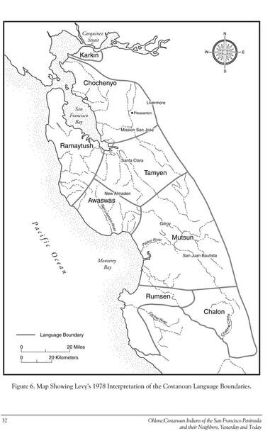
IntroductionBecause Ramaytush Ohlone territory is located along the San Francisco Peninsula and is bounded by water on its northern, eastern, and western sides, the only land border to determine is to the south. Conventional maps, like the one created by Levy in 1978 (below, right), show the southern boundary extending from (approximately) the mouth of Stevens Creek on the Bay side to just north of Point Ano Nuevo on the Ocean side. Randall Milliken (1995) locates the Ramaytush dialect of the San Francisco Bay Costanoan language along the San Francisco Peninsula, but does not specifically locate the southern boundary.
The evidence provided below shows that the southern boundary of the Ramaytush dialect was likely near the mouth of Stevens Creek on the Bay side and near Bean Hollow on the Coast side; however, for reasons that are explained below, the ARO considers San Antonio Road on the Bay Side and Pigeon Point on the Ocean side to be points along the coasts that mark our southern boundary. |
Indigenous Sovereignty"We are sovereign in our own land."
As the original peoples (i.e., First Nation) of the San Francisco Peninsula, we are sovereign in our own ancestral homeland. We hold an inherent right as the first peoples of the San Francisco Peninsula to self-governance and to cultural continuance (i.e., the right to determine our own way of life). Our Indigenous sovereignty pre-exists colonization and is not dependent upon federal recognition. Because we are under the political dominion of the United States Congress, we share sovereignty in our own lands with the United States as a nation, but we do not share sovereignty in our lands with any other sovereign entity, including other Native peoples. As in the past, we will defend our rights and responsibilities as Native peoples in our own land. |
|
Updated Map of Ramaytush Ohlone Territory (2023)
|
Richard Levy's map of Ramaytush Territory (1978)
|
Evidence for Ramaytush Territorial Boundaries
1. Ramaytush As a Polity
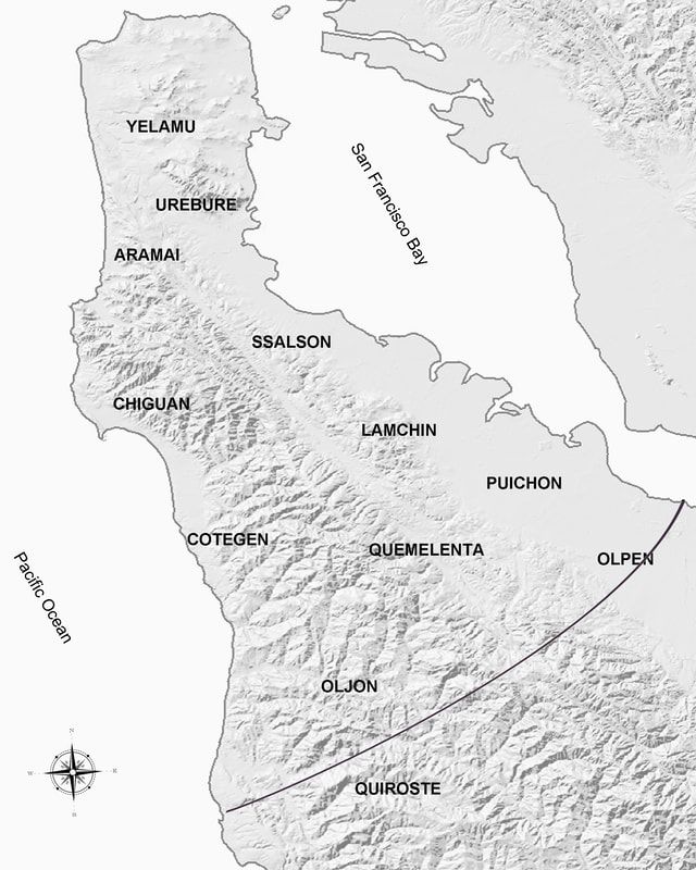
The Ramaytush peoples acted as an organized social and political entity within their linguistic territory.[1] In addition to heads at each individual village, the Ramaytush had a district leader who was the head of the Ramaytush district. The district leader, Luciano Tiburcio,was located at the village of Pruristac in the Aramai tribe. Manuel was the head of the Aramai village at Pruristac. In order to maintain relations among the independent tribes of the Ramaytush polity, the children of Luciano Tiburcio intermarried with the children of key village heads within Ramaytush territory. No other village/tribal head had children who intermarried more often with other village/tribal heads than Luciano Tiburcio. On the southern end of Ramaytush territory on the Bay side, the marriages included children from the village of Cachinigtac, a village shared by the Lamchin and Puichon tribes. The Lamchin and Puichon tribes were neighboring tribes and were closely related as proven in the mission records. Since Puichon territory extended to the area just south of San Francisquito Creek to approximately the Palo Alto Airport, its southern boundary marks the know southern boundary of the Ramaytush polity. Intermarriages with the Oljon tribe, whose southern boundary extended to Bean Hollow on the Ocean side, mark the southern boundary of the Ramaytush polity on the Ocean side.
Additional evidence of the Ramaytush polity can be proven by their dominance as staff at Mission Dolores. From 1785, at which time they entered Mission Dolores, until just after 1800, by which time most Ramaytush had died, the children of Luciano Tiburcio and Manuel dominated positions of leadership in the mission staff at Mission Dolores. The leadership extended to spouses of Luciano Tiburcio and Manuel's children as well. As might be expected, Ramaytush families continued to intermarry with one another at Mission Dolores just like they had prior to the invasion of the Spanish until high death rates severely limited the choice of marital partners. In other words, the political authority exercised by the district leader, Luciano Tiburcio, and tribal head, Manuel, continued even at Mission Dolores.
In sum, evidence from the mission records clearly indicates that the Ramaytush existed as a distinct social and political entity within their linguistic territory. While each independent tribe had its own leadership, the district head of the Ramytush Ohlone maintained social and political relations through the intermarriage of his children across the whole of Ramaytush territory. Marriages with the children of other village/tribal heads confirm the southern boundary as being the southern edge of Puichon territory on the Bay side and the southern edge of Oljon territory on the Ocean side.
[1] The same pattern existed elsewhere in California, including the Humaliwo and Lulapin districts in Chumash territory.
2. Linguistic Boundaries: Pedro AlcantaraBaptized at Mission Dolores in San Francisco 25 September 1786 (SFD-B:553), Pedro Alcantara was born a month earlier at the village called Ssalaime “on Purisima Creek on the Pacific Coast, south of Half Moon Bay” (Milliken 1995:242). His brother was born at village of Timigtac along Calera Creek. Alcantara’s father, Gonzalo Simmòn (SFD-B:534), originated from the village of Torose near Ssalaime. His mother, Restituta Juuim (SFD-B:535) came from the village of Chutchui of the Yelamu in present-day San Francisco. The couple renewed their marriage at Mission Dolores 22 April 1786 (SFD-M:126).
In his interview Pedro Alcantara claimed to be a member of the Romanon tribe, which is a mis-hearing/mis-spelling of Ramai-non. Ramai is the root word for west. Tribal peoples were often referred to by the location of their tribe relative to the tribe making the reference. Two persons baptized from the Aramai tribe refer to their place of origin as Aramai, as being "from the west." In this case, the Romanon tribe refers to the combination of three tribal designations currently used by scholars and others: the Aramai, the Chiguan, and likely the Cotegen. Since the Aramai and Chiguan tribes were headed by brothers, and since the head of the Aramai tribe was born in Chiguan territory, it is likely that the two were considered one tribal community by their own members. The Cotegen tribe, south of the Chiguan, was likely a continuation of the larger tribe. The villages of Ssalaime and Torose were located in Cotegen territory. |
3. Ethnic DifferencesPersons who spoke the Chochenyo dialect of the San Francisco Bay Costanoan language referred to the Ramaytush as people from the San Francisco side of the Bay. Also, they noted differences between the dialects--between Chochenyo and Ramaytush. In other words, the Chochenyo differentiated the Ramaytush from themselves as a people who spoke a different dialect. |
Pacific Ocean Side Location:
|
San Francisco Bay Side Location:
|
|
The southern boundary of Ramaytush Ohlone territory on the Pacific Coast side is specifically located at Bean Hollow along the Pacific Ocean along at shared border between the Oljon tribe and the Quiroste tribe.
Like the Olpen, the Quiroste are considered a transitional group between the Ramaytush- and Awaswas-speaking peoples. Quiroste territory, therefore, is considered shared between the Ramaytush- and Awaswas-speaking peoples. Instead of sharing Quiroste territory with the Awaswas, which often leads to confusion, the Ramaytush Ohlone have decided to divide Quiroste territory with the Awaswas. Our southern boundary on the Ocean side, therefore, is located at Pigeon Point. |
In the document above, Pedro Alcantara identifies the southern boundary of Ramaytush territory at "the head of the San Francisco Bay." While the head could be located at the furthest southern point, at the mouth of the Guadalupe River, a more conservative estimate places the head closer to the mouth of Stevens Creek.
The Olpen tribe is located just north of Steven's and is considered to be a transitional group between the Ramaytush- and Tamien-speaking peoples. Olpen territory is, therefore, considered shared territory between the Ramaytush Ohlone and Tamien Nation. Instead of sharing Olpen territory with the Tamien Nation, which often leads to confusion, the Ramaytush Ohlone have decided to divide Olpen territory with the Tamien Nation. Our southern boundary on the Bay side begins at San Antonio Road, then moves west along Charleston and Arastradero Roads, then west along Page Mill Road to Skyline Boulevard. |